
Neolithic Age
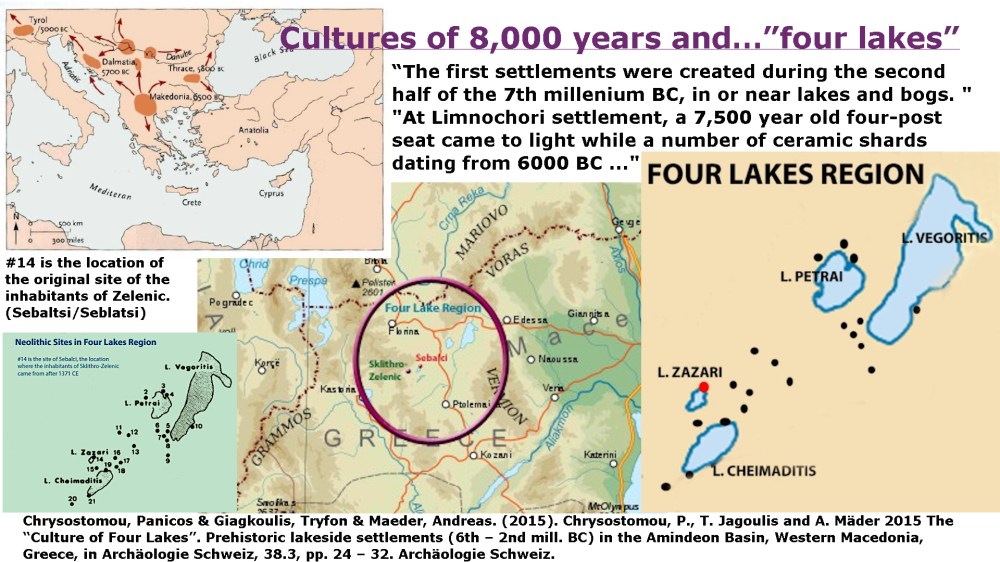
The original inhabitants to the present site of Sklithro-Zelenic first came from the settlement that was known as Sebalci on lake Zazari (Zazerci – Sarigol), present day settlement of Limnohori (Sveti Todori & Cerkeskoj). The inhabitants of this settlement fled the area after it was burnt down by the Ottomans in after 1371 (refer to the Medieval Period more specific information).
Macedonia 508 BCE

The settlement of Sebalći–Zelenich was located in the region of Eordaea, within the Four Lakes Region of Upper Macedonia. During the first stage of Macedonian expansion, roughly between 650 and 550 B.C.E., this inland area gradually came into the sphere of Macedonian control. By about 520 B.C.E., expansion moved decisively west of Mount Vemion into Eordaea, a strategically important region because it lay at the junction of major routes. These included the Bitola–Kozani corridor, the main east–west route later known in Roman times as the Via Egnatia, and the Klisoura Pass, which connected Eordaea westward to Lake Kastoria and Orestis. This position made Eordaea, and settlements such as Sebalći–Zelenich, vital to movement, trade, and regional integration in ancient Macedonia.
Macedonia After 478 BCE
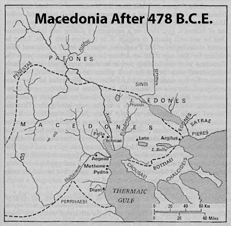
The settlement of Sebalći–Zelenich lay in the region of Eordaea, within the Four Lakes Region of Upper Macedonia, an area that became firmly integrated into the Macedonian kingdom by the late sixth and fifth centuries B.C.E. During the reign of Alexander I “Philhellene” (498–454 B.C.), Macedonia expanded its territory while participating as a Persian ally in the Greek–Persian wars, strengthening control over inland regions such as Eordaea. His son Perdiccas II (453–413 B.C.) pursued an active and often disruptive foreign policy, instigating rivalries between Athens and Sparta that contributed to the outbreak of the 27-year Peloponnesian War, a conflict that left much of the Greek world exhausted. Under Archelaus (413–399 B.C.), Macedonia emerged as a growing economic power, with major administrative reforms and a reorganization of the army, developments that further consolidated regions like Eordaea and supported the stability and continuity of settlements such as Sebalći–Zelenich.
Ancient Macedonia – Eordaea
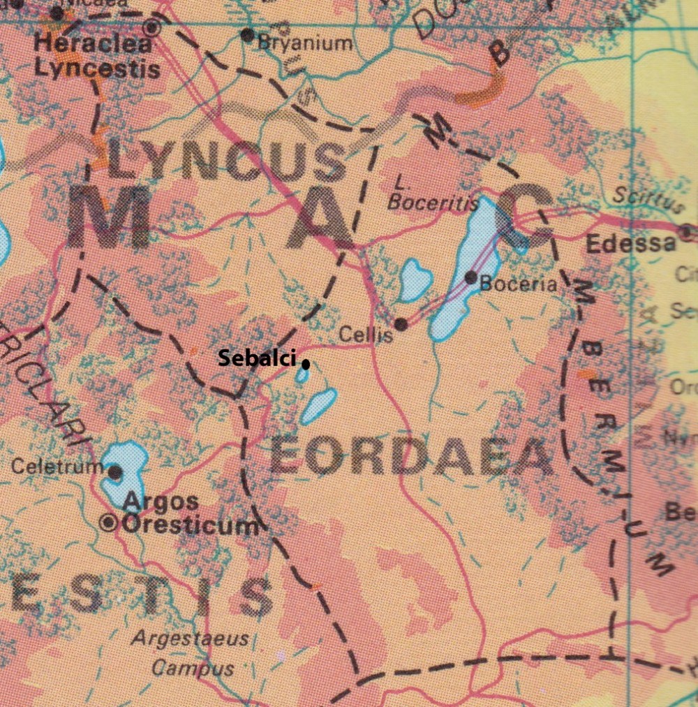
During the Macedonian period, Ancient Macedonia included the region of Eordaea, part of Upper Macedonia along with Lynkestis and Orestis. Eordaea was a mountainous, lake-rich landscape that supported early agricultural and pastoral communities and played an important role in the inland structure of the Macedonian kingdom. The settlement of Sebalći, identified on the map as the original site of Sklithro–Zelenich, was inhabited by indigenous Upper Macedonian populations and shows continuity of occupation from before and throughout the Macedonian period. This continuity highlights how rural communities such as Sebalći formed the lasting social and economic foundation of ancient Macedonia beyond its royal centres.
Macedonia 200 BCE
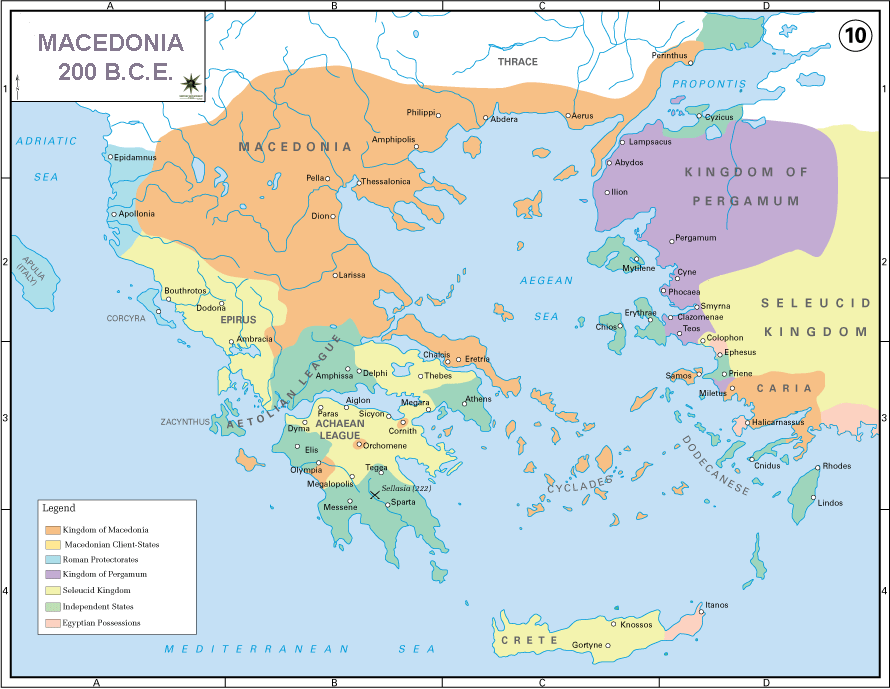
During the reigns of Philip V and his son Perseus, Macedonia entered its final period of independence as Rome emerged as a decisive power in the eastern Mediterranean. Between 214 and 148 B.C.E., a series of conflicts were fought between the Roman Republic, supported by Greek allies, and the Macedonian kingdom, gradually weakening Macedonian authority. Rome advanced into the Balkans using strategic land routes, in a manner comparable to later invasions through Albania into Greece, allowing Roman forces to penetrate and isolate Macedonia. These wars ended with the defeat of Perseus and the subjugation of Macedonia, bringing an end to the ancient Macedonian kingdom and marking the beginning of Roman dominance in the region.
Roman Conquest
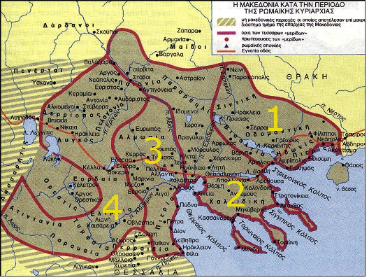
After the Fourth Macedonian War, which began with a rebellion led by a man claiming to be the son of Perseus, Rome intervened once more and this time remained in Macedonia permanently. The kingdom was abolished and divided into four separate republics to prevent any resurgence of Macedonian power, with the fourth region consisting of Eordaea, Lyncus, and Pelagonia, the area in which Sebalći–Zelenich was located. According to the Roman historian Livy, this region was marked by a cold climate, rugged terrain, and a fiercely independent population. Physical barriers and tightly controlled mountain passes isolated each republic, while Roman armies guarded the routes that became part of the Via Egnatia. Economic restrictions were imposed through bans on mining gold and silver, limits on timber logging, heavy taxation, and the confiscation of private and public wealth, measures that enriched Rome and weakened Macedonia. The deportation and enslavement of the Macedonian elite further ensured that no organized national resistance could re-emerge.
Via Egnatia
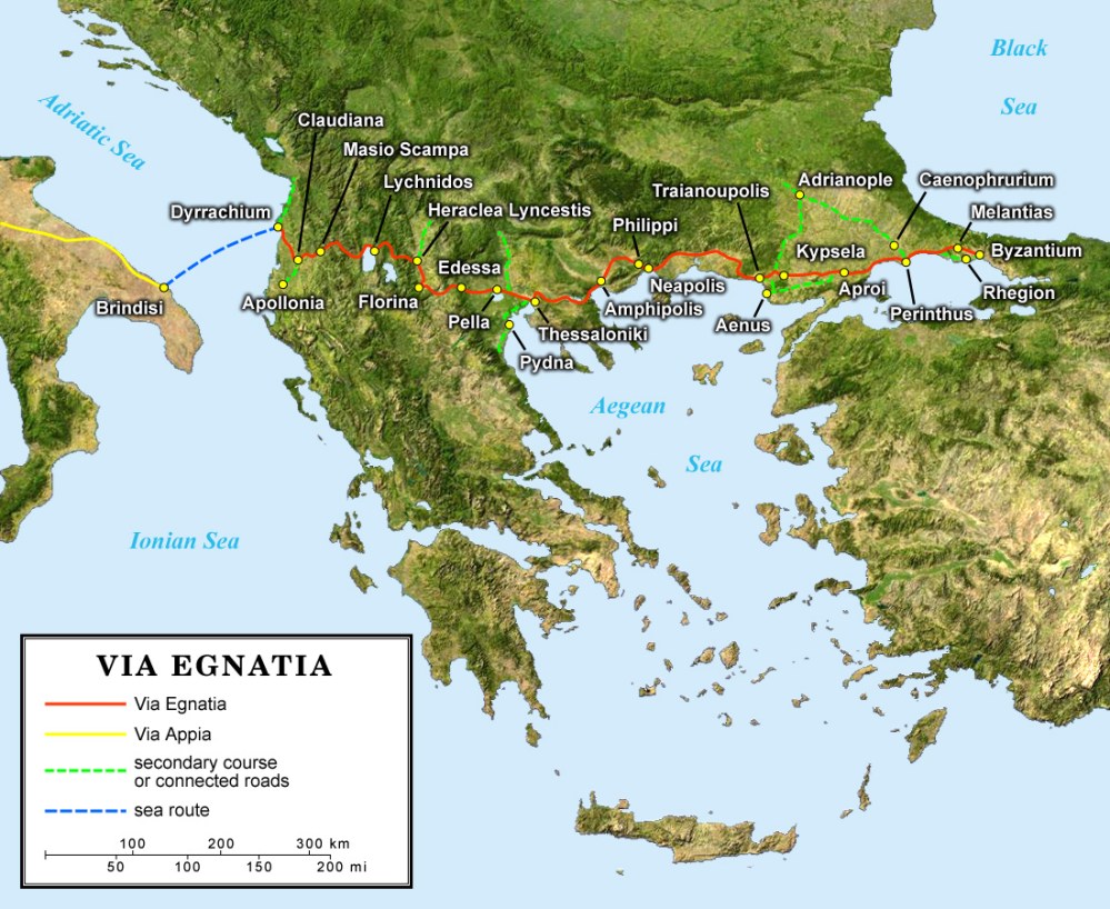
The construction of the Via Egnatia transformed the economy of Eordaea by linking inland Macedonia to major Adriatic and Aegean routes, bringing Roman administration, merchants, and new markets into the region. This major thoroughfare passed only about 15 km from Sebalći, making the settlement well positioned to benefit from increased trade, mobility, and agricultural exchange. Under Roman rule, the combination of roads, estates, and administrative organization produced an economic boom that enriched both local elites and lower classes, within a society centered on agriculture and slave labor. In the area of Sebalći, on Lake Zazari, archaeological evidence of a Macedonian and later Roman bath on the northeast side of the lake suggests the presence of a Roman rural estate, likely tied to farming activity. Such estates reflected the Roman idealization of agriculture as both an economic necessity and a prestigious way of life, integrating Sebalći into the wider Roman economic landscape shaped by the Via Egnatia.
Roman Empire 117 CE
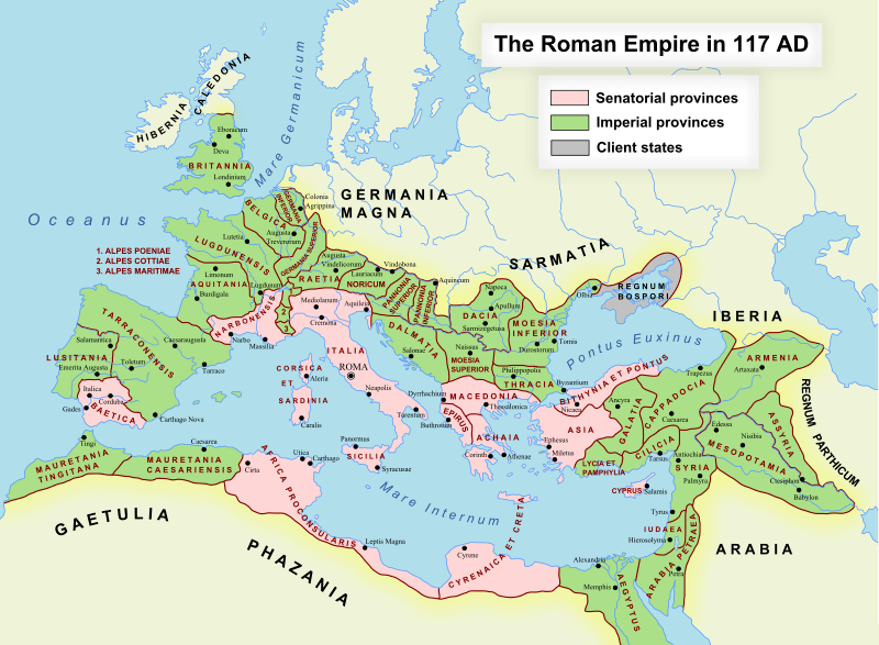
By the height of the Roman Empire in the second century AD, Eordaea lay firmly within the Roman provincial system, a region rich in arable land and mineral resources yet marked by deep social disruption. Despite its agricultural potential, many Macedonians—especially members of the elite, educated classes, and military leadership—were enslaved and transported to Rome, while those who remained were compelled to labor in agriculture or the region’s mines under harsh conditions. This widespread suffering endured by the Macedonian population is reflected in early Christian tradition, most notably in the vision described in Acts, when the Apostle Paul is said to have seen “a man of Macedonia” pleading for help, a moment that symbolically captures the distress and spiritual longing of Macedonia under Roman rule.
535 CE Justiniana Prima
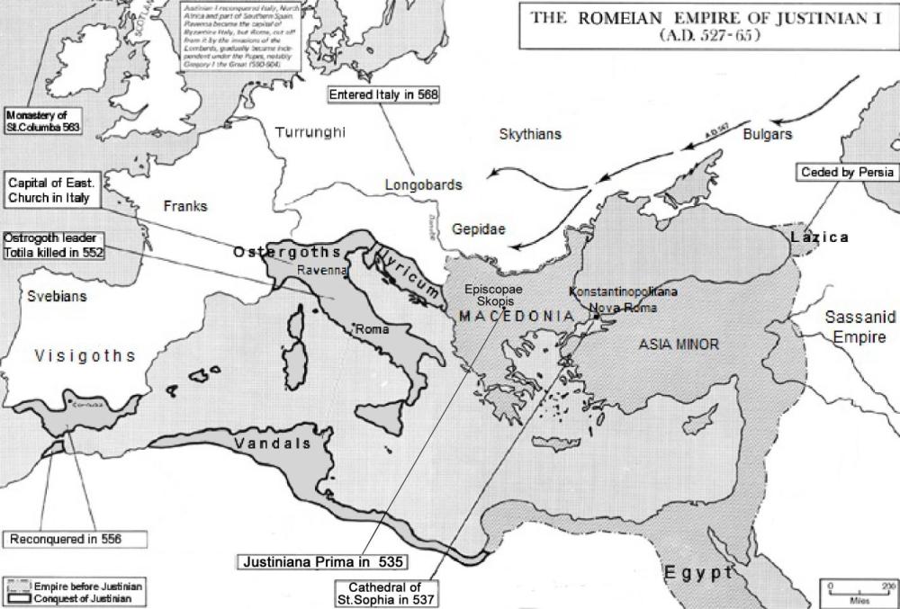
During the early Byzantine period, imperial power was largely shaped by rulers from the Balkans, many of Macedonian origin, reflecting the central role of Macedonia within the Eastern Roman Empire. Constantine the Great was identified as Macedonian by Ioannes Lydus, who noted that Constantine wrote in his native language, at a time when Latin was already receding in Constantinople, while Greek was widely spoken alongside local tongues. Two centuries later, Emperor Justinian I, himself of Balkan and Macedonian background, reportedly spoke imperfect Latin and Greek, underscoring the linguistic diversity of the capital. In 535 C.E., Justinian formally elevated the Macedonian Apostolic Church by granting autocephalous status to the Archiepiscopacy of Justiniana Prima, centered on Skopje, placing it on equal footing with the major apostolic sees of the Christian world. This imperial decree removed much of Macedonia from Rome’s ecclesiastical influence, deepened the division between Eastern and Western Christianity, and marked a lasting shift in religious and political authority—significantly enacted by an emperor of Macedonian origin.
800 CE Map
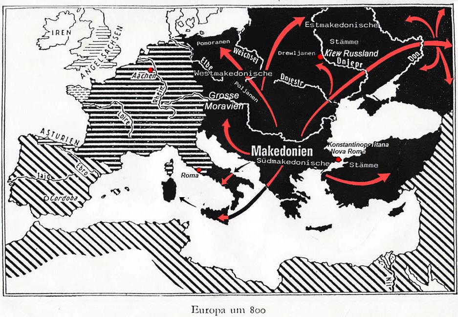
As illustrated by the spread shown on the map, Macedonic cultural and religious influence radiated widely across the Balkans and into central Europe during the 9th century, largely through the work of Saints Cyril and Methodius. Although Constantinople initially sought to subjugate and Romanize the Macedonians through colonization, Latin administration, and ecclesiastical control, these efforts faltered due to strong linguistic and cultural affinities among the local population. The vernacular Macedonic liturgical language and the reformed Glagolitic script—later simplified into Cyrillic by the disciples Naum and Kliment of Ohrid—proved far more accessible and spiritually resonant. Originating from Thessaloniki and deeply rooted in the Macedonian linguistic environment, Cyril and Methodius carried this rite and script first to Raška and then to Great Moravia, where it was adopted as a means of Christian instruction in a language people could understand. Recognizing its immense popularity and unifying power, the Byzantine authorities ultimately embraced the Macedonic rite and script as instruments of influence, facilitating their diffusion across the Macedonian Peninsula and central Europe during the height of the Macedonian Dynasty.
Tsar Samuel 968-1018 CE
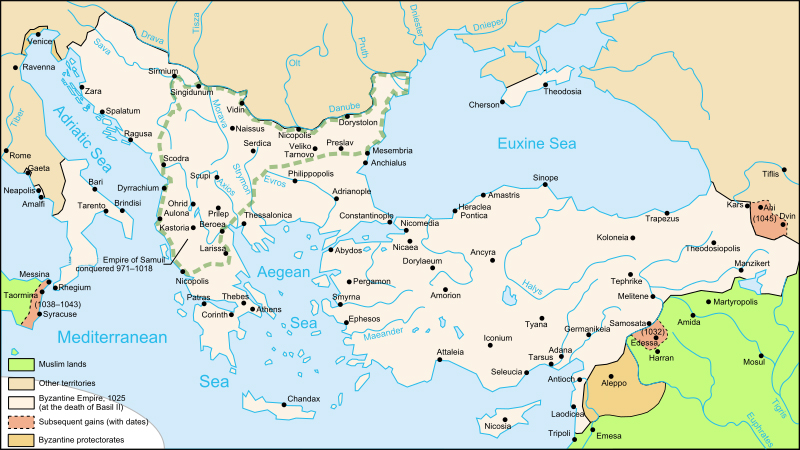
The map illustrates the rise of Tsar Samoil and the second Macedonian state, which emerged from the Komitopuli rebellion at the end of the tenth century, a movement rooted in regions where Bogomilism was strongest, particularly the triangle formed by the Vardar River, Lake Ohrid, and Mount Shar. Supported by the Bogomils—an organized anti-Byzantine and anti-Bulgar movement with a strong Macedonian orientation—Samoil and his brothers broke Macedonia free from foreign domination and established a powerful indigenous state. During Samoil’s forty-year reign, his empire expanded from the Adriatic to the Black Sea and from Thessaly to the Danube, with ecclesiastical centers at Ohrid and Prespa, where Bogomil communities were incorporated into a reformed Macedonian church. Although feudal in structure, the state drew much of its strength from popular religious and social support, gaining international recognition by the end of the tenth century, before ultimately facing destruction through combined Eastern and Western Roman opposition to its political independence and religious tolerance.
Bogomils
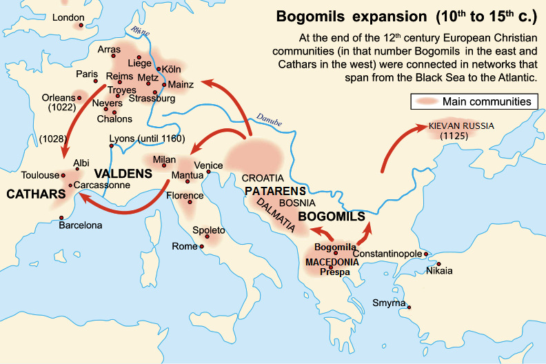
The map highlights the wide diffusion of Bogomilism from its origins in Macedonia in the mid-10th century across the Balkans and into central and western Europe, where related movements such as the Patarens and Cathars emerged. This spread unfolded during the Macedonian dynasty of the Eastern Roman Empire (867–1056), a period in which emperors of Macedonian descent governed within a Roman political framework shaped by Greek philosophy, while new forms of local religious and social consciousness took root in the Balkans. Bogomilism arose under conditions of intense feudal and ecclesiastical oppression in Macedonia—then under Bulgar rule—and articulated a radical critique of feudal power, church wealth, and social hierarchy, promoting freedom of conscience, equality, and communal ethics. Drawing on strands of classical philosophy and medieval spiritualism, it became a major challenge to official Christianity and the feudal order, spreading along networks that linked the Black Sea to the Atlantic and continuing to influence European religious life for centuries.
1020 Patriachate of Ohrid
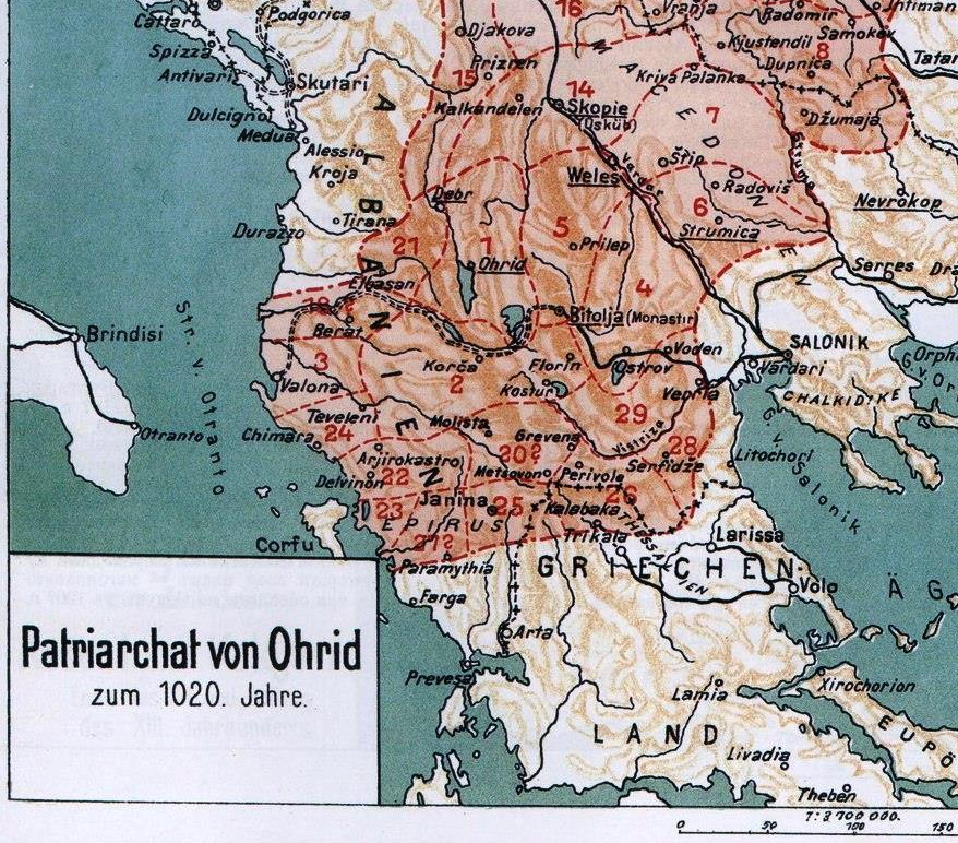
The map of the Archbishopric of Ohrid around the year 1020 illustrates the extensive ecclesiastical structure of the Macedonian Apostolic Church, including the Kostur eparchy (#2), which governed the area around Sebalći and, according to oral tradition, remained a point of memory for the inhabitants who later settled in Zelenich (Sklithro). The growing independence and influence of this church, strengthened under Tsar Samoil, was ultimately challenged by Emperor Basil II, who after nearly forty years of warfare destroyed Samoil’s Macedonian Empire and reasserted Roman control over Macedonia. Yet, following his victory, Basil II adopted a notably moderate policy, confirming the privileged and largely autonomous status of the Ohrid Archiepiscopacy in deliberate opposition to Roman papal interference. Through his imperial Bulls of 1019 and shortly thereafter, Basil II confirmed a total of thirty-one eparchies, listing their sees, towns, clergy, and faithful, thereby preserving Macedonian ecclesiastical continuity. This structure also safeguarded the liturgical use of Old Church Slavonic, a literary language rooted in Old Macedonian dialects, which later spread far beyond Macedonia and became the sacred written language of much of the Slavic Christian world.
Battle of Maritsa (Chernomen), 1371
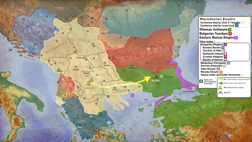
The map illustrates the political fragmentation of the Balkans on the eve of the Battle of Maritsa in 1371, a decisive event that sealed the fate of Tsar Vukašin and accelerated the Ottoman advance into Macedonia. At the time, rival kings, despots, and lords ruled independently without unity, leaving the region vulnerable. Vukašin (1366–1371), the most powerful among them, proclaimed himself king of Macedonia and Greece and moved east to confront the Ottomans in the Maritsa valley near Chernomen, between Philippopolis and Adrianople. On the night of 26 September 1371, Ottoman forces launched a surprise dawn attack that resulted in a crushing defeat for the Christian armies, made possible by the Ottomans’ centralized command and their standing army, including the Janissary corps. Vukašin was killed in the battle, and the defeat shattered organized Macedonian resistance. His son and successor, Marko Kraljević, was compelled to accept Ottoman vassalage, marking a turning point that opened Macedonia to sustained Ottoman domination.
King Vukasin & Krajl Marko
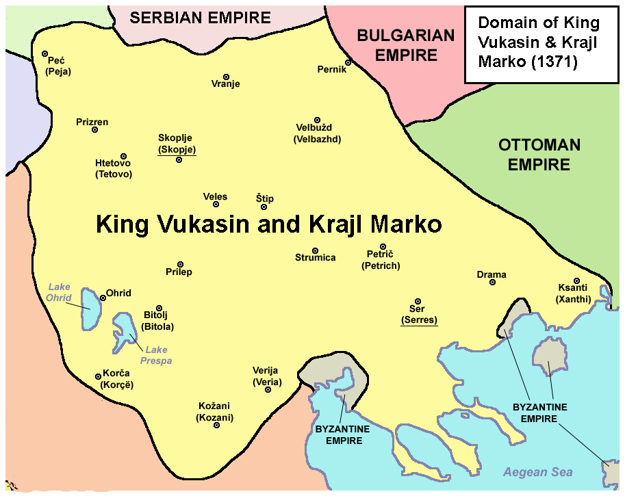
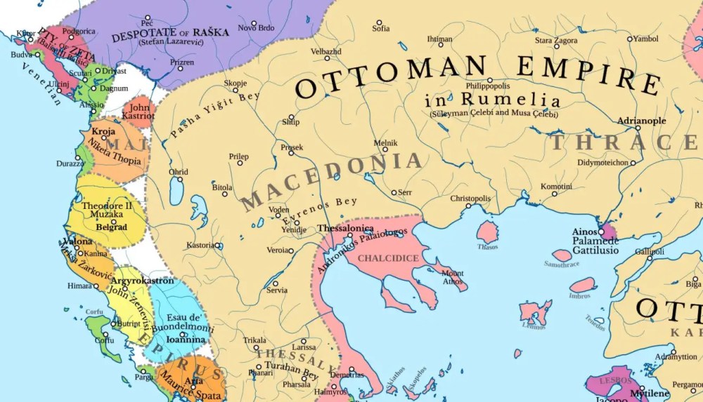
The map illustrates the final phase of medieval Macedonian rule and the rapid Ottoman advance into the Balkans during the mid-to-late 14th century. Ottoman expansion began decisively in 1352–1354, when Suleyman, son of Orhan, secured Adrianople and the fortress of Gallipoli, firmly establishing Ottoman power on European soil and opening the way for conquest of Thrace, Macedonia, and the wider Balkans. Geographic realities shaped this advance, as Ottoman forces followed the historic Via Egnatia westward through Serres, Monastiri (Bitola), and Ohrid toward the Adriatic. This invasion coincided with deep political fragmentation, as local rulers governed independently without unity, including King Vukašin, who briefly ruled much of Macedonia and Greece (1366–1371). His defeat by Ottoman forces at the Battle of Maritsa in 1371 marked a turning point, after which his son Marko Kraljević became an Ottoman vassal under the empire’s feudal system. Following Maritsa, Macedonian regions fell progressively, and the ancient region of Eordaea—encompassing Florina, Kastoria, and Ptolemaida—was conquered around 1385–1386, bringing centuries of medieval Macedonian autonomy to an end.
Realm of King Marko
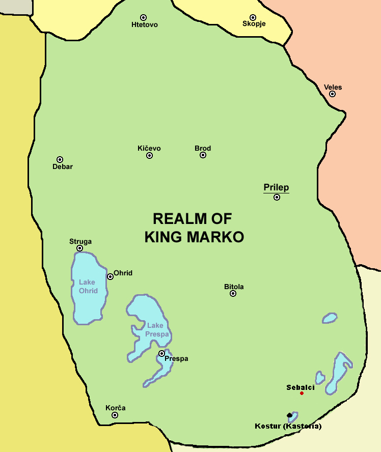
After the defeat of Tsar Vukašin at Chernomen in 1371, the Balkan principalities gradually accepted Ottoman suzerainty, and by 1377 his son King Marko ruled western Macedonia as an Ottoman vassal. Although politically constrained, Marko acted as a traditional Christian ruler, sponsoring the Monastery of Saint Demetrius near Skopje in 1376, while the destruction of regional castles left his realm exposed to raids and insecurity. In the 1390s, nomadic Yörük shepherds from Asia Minor settled across Macedonia, especially in the Kayjal–Ptolemaida region, further reshaping the landscape. Fulfilling his vassal obligation, King Marko fought for Sultan Bayezid and was killed on May 17, 1395, at the Battle of Rovine, leaving Macedonia without a king and marking the end of its political freedom under indirect rule. From this moment emerged the legend of Kralj Marko, preserved in the oral history of Sebalći and later Zelenic (Sklithro), where landmarks near Lake Zazari continue to anchor the memory of a tragic ruler who, according to tradition, prayed for the Christians even as he faced his own death.
1300 CE Castles WM

The map shows the castles of Western Macedonia and the dates of their overthrow during the Ottoman advance of 1385–1386, a period remembered in local oral history as one of destruction and flight. According to tradition, the inhabitants of Sebalći refused to submit, and after the settlement was burned, they scattered into the surrounding forests seeking refuge. Similar memories are preserved in Aetos (Ajtos), Agrapidies (Goricko), and Nymfeo (Neveska), whose founders likewise fled the plains and resettled in remote, forested locations. From this upheaval emerged the village of Zelenich (Sklithro), founded between about 1385 and 1395 by families escaping the Zazari Lake area, who remained hidden in the mountains for nearly a century. Oral tradition recounts how secrecy was essential to survival—fires at night were forbidden—and how a ritual marking the village boundaries with twin heifers and twin boys was believed to protect the new settlement. While many nearby villages were later destroyed by war or disaster, Zelenich endured, preserving both its physical continuity and the memory of its founding under Ottoman pressure.
The map reflects Ottoman Macedonia in the late 15th century, when the first written record of the mountain villages appears in the 1481 Ottoman defter (tax register). These settlements emerged as a result of repeated revolts and heavy taxation in the plains, forcing the reaya to abandon exposed areas and seek refuge in the mountains. Oral tradition recounts that as Ottoman authorities expanded taxation beyond the valleys, villages such as Aetos (Ajtos) and Agrapidies (Goricko) were registered first, followed by Nymfeo (Neveska); upon seeing smoke rising from the valley below, officials descended to Zelenic (Sklithro) and registered it as well, increasing revenue from Christian households, who alone were taxed. Some villages received tax privileges in exchange for road maintenance or frontier duties, and Nymfeo in particular gained a special role after Vlach populations were settled there as mountain guards overseeing the valleys. Over time, expanded cultivation made the Zelenic valley economically attractive, leading to increased Ottoman exploitation, the settlement of Yörüks in the area, and the displacement of villagers to the western side of the Eleovo (Lehovo) creek as Muslims claimed the original site.
The Yörük
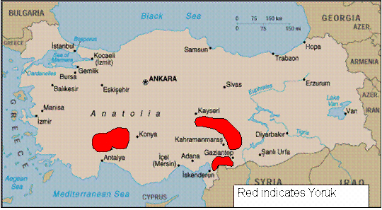
The map highlights the Anatolian regions west of Konya identified with Yörük populations, from which the Muslim inhabitants of Zelenich are believed to have originated. According to historical and oral tradition, Yörüks settled in Zelenich after 1481, following the Ottoman consolidation of Macedonia. The Yörüks were a Turkish nomadic subgroup, primarily pastoralists, who moved seasonally and later became established in mountainous areas of the Balkans. Large numbers migrated from the Konya district into Macedonia, including the Kailar region around Kozani and modern Ptolemaida, with further waves continuing intermittently until the mid-18th century. After the introduction of the Ottoman feudal system in 1397, Seljuk noble families from Asia Minor also crossed into the Balkans, and some Muslim landowning families in southern Macedonia before the Balkan Wars are thought to have descended from these early Anatolian settlers.
1750 – 1850 Vlach Movement into Macedonia
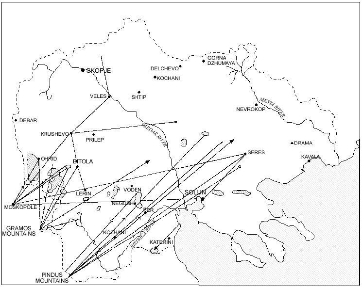
Between 1750 and 1850, Macedonia experienced successive waves of population movement as a result of political instability, banditry, and competing national ambitions, making it a contested land and people. Vlachs and Christian Albanians were driven from Epirus and areas stretching from Moskopole to the Gramos Mountains by sustained violence from Albanian Muslim irregulars, especially during the era of Ali Pasha. Many sought refuge in Western Macedonia, where new villages such as Lehovo (Eleovo) and Nymphao (Neveska) were established or expanded alongside existing Macedonian settlements like Zelenic. Oral history records that Christian Albanian families were permitted to settle only on specific slopes near Zelenic, while Vlachs from Moskopole and surrounding regions were pushed to higher mountain locations. Despite widespread suffering and upheaval across Western Macedonia during this period, Zelenic itself remained largely untouched, likely due to a fragile but enduring understanding between its Christian and Muslim inhabitants, allowing the village to preserve stability amid regional anarchy.
1800 Macedonian Vilayets
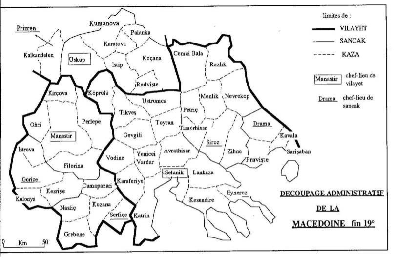
Victor Bérard (1864–1931) was a French writer and political commentator who traveled extensively in Ottoman Macedonia during the 1890s and gradually came to support the principle that Macedonia should develop freely on its own terms, captured in the phrase “Macedonia for the Macedonians.” In his analysis, Macedonia was not defined by a single administrative unit but by a historical and geographic reality that spanned several Ottoman provinces. By the late nineteenth century, Ottoman reforms had divided the Macedonian region primarily among three vilayets: Selanik (Salonica/Thessaloniki), Monastir (Bitola/Monastir), and the northern areas included in the Vilayet of Kosovo, with centers such as Priština and later Uskub (Skopje). A map based on Bérard’s framework therefore presents Macedonia as a coherent region crossing these vilayet boundaries, emphasizing key administrative and communication hubs—Salonica, Monastir/Bitola, Skopje/Uskub, and Priština—and highlighting its role as a strategic crossroads shaped by major routes, especially the Morava–Vardar axis, and by competing national influences at the end of the nineteenth century.
1856-1878 Map

1900 Western Macedonia
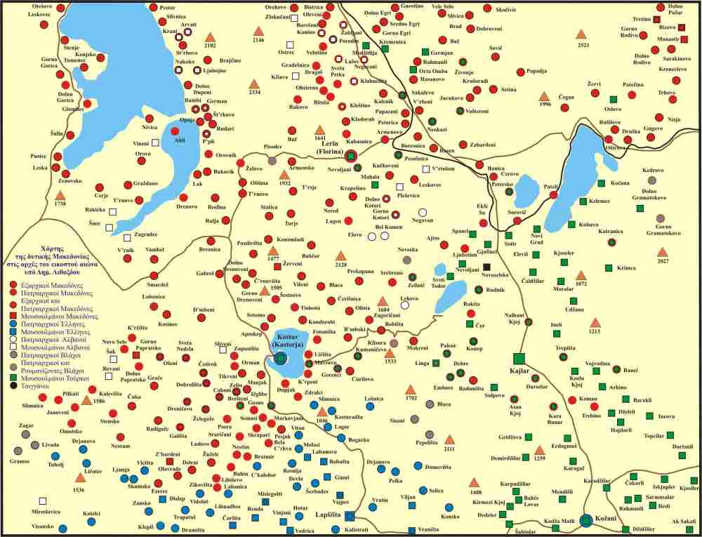
The map illustrates the late 19th–early 20th century struggle over Macedonia between two external forces—the Patriarchate of Constantinople and the Kingdom of Greece on one side, and the Bulgarian Exarchate on the other—both competing for influence over the native Christian population. Using the Ottoman Rum system, which classified all Orthodox Christians as “Greek” by religion, the Patriarchate sought to preserve Greek ecclesiastical dominance, while the Greek national state aimed to extend its political borders. After 1870, the Bulgarian Exarchate entered the contest, intensifying rivalry through church affiliation, schools, armed bands, and coercion. Although Greek dominated urban churches and Old Church Slavonic prevailed in rural Macedonian villages, people were forced to declare themselves either Greek or Bulgarian, regardless of their actual Macedonian, Vlach, or Albanian identity. The map visually records this imposed division of faith and allegiance, revealing how ecclesiastical and national rivalries fractured Macedonian society and undermined its emerging national consciousness.
Macedonian Revolutionary Movement 1893-1912
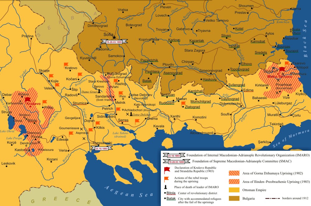
The map titled “Macedonian Revolutionary Movement 1893–1912” illustrates the emergence, organization, and geographic spread of the Internal Macedonian Revolutionary Organization (VMRO) and culminates in the Ilinden Uprising of 2 August 1903. Founded in Salonika in 1893, the VMRO sought the liberation of Macedonia and the creation of an autonomous or independent homeland, free not only from Ottoman rule but also from Greek, Bulgarian, and Serbian interference that divided the Macedonian population along ecclesiastical and political lines. Through a secret, hierarchical network of regional, district, and village committees, the organization prepared the population for revolt, with villages such as Zelenich maintaining local voivodes and armed units (četi) to provide security and readiness. The map reflects both the internal revolutionary structure and the intense external pressure from rival Greek, Bulgarian, and Serbian organizations that attempted to undermine Macedonian self-identification. Despite internal divisions, foreign manipulation, and the loss of key leaders such as Goce Delčev, the uprising erupted in the Bitola vilayet at Ilinden, briefly establishing the Krusevo Republic and marking a defining moment in the Macedonian struggle for self-determination.
1912 Map
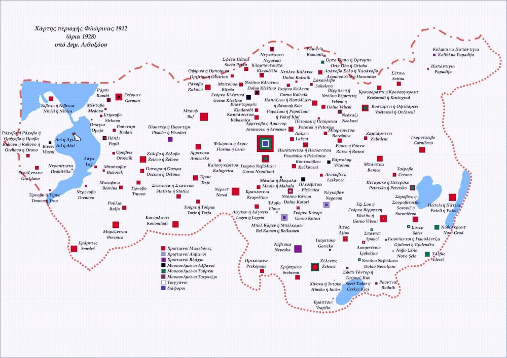
This map of the Florina–Kastoria region in 1912 illustrates how religion, rather than abstract ideology, became the primary instrument through which national identities were imposed on the rural Macedonian population in the final years of Ottoman rule. Churches, clergy, and sacred spaces functioned as the central battleground, where control over liturgy, schools, and sacraments translated directly into control over communal loyalty and the shaping of identity. Acts such as defrocking priests, confiscating liturgical books, or attacking churches during mass were deliberate strategies aimed at breaking traditional Macedonian religious life and replacing coexistence with rigid, armed boundaries aligned to Greek, Bulgarian, or Serbian agendas. As external forces exploited the Rum system and later the chaos fostered by Young Turk policies, villages were pressured through bribes, intimidation, and violence to “choose” an identity, often against their will. The map visually captures this fragmentation on the eve of the Balkan Wars, when escalating religious and paramilitary conflict dissolved local harmony and paved the way for the partition of Macedonia in 1912–1913.
First Balkan War 1912
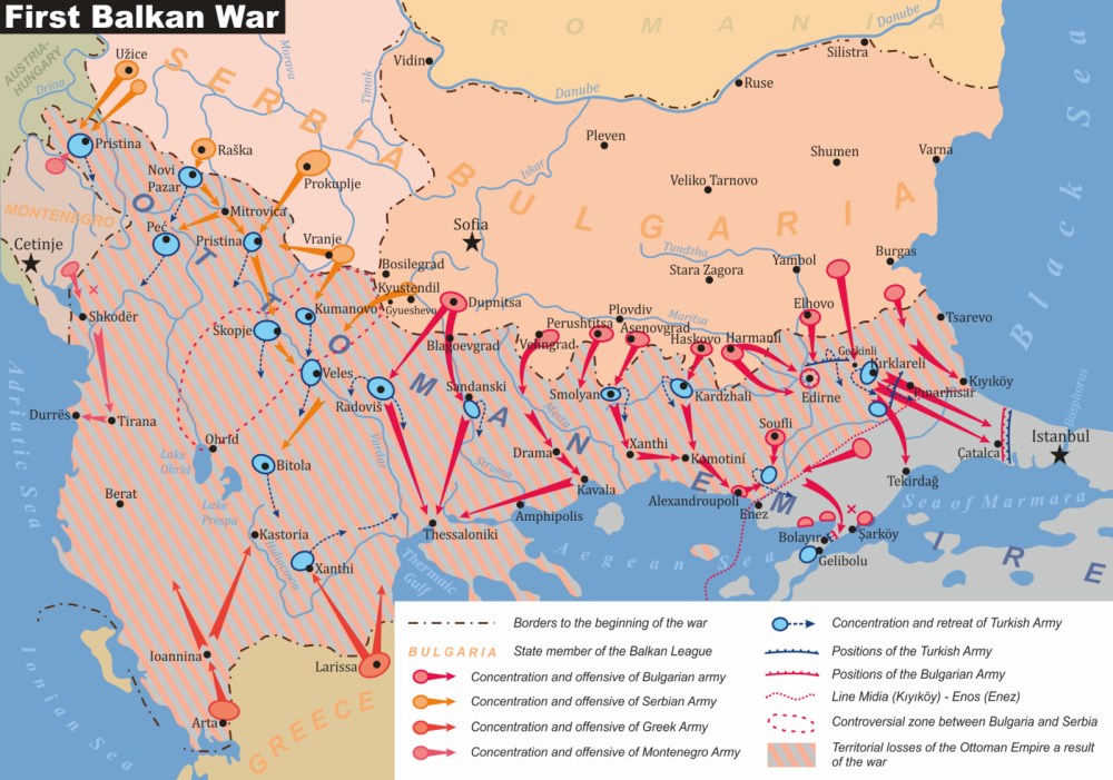
As illustrated on the map, the First Balkan War unfolded largely across Macedonian territory, turning the region into the principal battlefield of competing Balkan armies. After Montenegro declared war on the Ottoman Empire on 8 October 1912, Bulgaria, Serbia, and Greece followed on 18 October, launching coordinated offensives as members of the Balkan League. Bulgarian forces—over 350,000 strong—advanced primarily southward toward Adrianople (Edirne) and Salonika, while Greek armies, numbering nearly 110,000, pushed north to seize Salonika. Serbia divided its 230,000 troops into three armies advancing toward Kumanovo and Monastir (Bitola), and Montenegro’s 35,000 men moved eastward into western Macedonian areas. Despite Ottoman resistance on two fronts—Thrace and Macedonia—the League achieved a swift and unexpected victory within six weeks, decisively defeating Ottoman divisions at Kumanovo and Bitola. Crucial to this outcome were Macedonian militias, including over 14,000 volunteers fighting under Bulgarian command in the east and numerous detachments assisting Greek and Serbian forces by harassing Ottoman retreats. Many Macedonians initially welcomed the League as “liberators,” encouraged by propaganda and promises of freedom, and thousands enlisted, including volunteers from villages such as Zelenich in the Macedonian–Adrianopolitan Volunteer Corps. Yet the map’s post-war reality foreshadowed disillusionment: Macedonian fighters were deployed away from their homeland, autonomy demands—such as Sandanski’s call on 12 December 1912—were ignored, and occupying armies imposed control and assimilation, sowing bitterness that led to widespread desertions on the eve of the Second Balkan War.
Greek Army Enters Zelenich
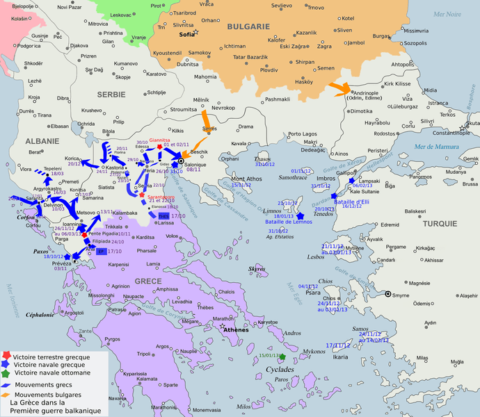
As shown on the map, the Greek army advanced rapidly into Western Macedonia in October–November 1912, prioritizing the race to Salonika while securing the western Macedonian hinterland. Crossing the border on 6 October, Greek forces reached Kozani by 11 October, with the 5th Division pushing north through Kailari (Ptolemaida), Sorović (Amyntaio), and the Kirli Derven (Kleidi) Pass, exploiting the general Ottoman retreat. After a brief setback against Ottoman counterattacks near Lofoi, Greek forces regrouped, resumed their advance, and by early November captured Edessa (Voden), Florina (Lerin), Kastoria, and surrounding villages, entering Zelenich (Sklithro) on 10 November 1912. Initially welcomed as liberators, Greek troops and accompanying paramilitary bands soon imposed coercive measures: confiscating Cyrillic religious books, threatening villagers to abandon the Exarchate for the Patriarchate, and employing intimidation documented in contemporary reports, including those later cited by the Carnegie Commission. In Zelenich, collective resistance—most notably by village women who physically protected St. George’s Church—prevented its destruction, symbolizing the abrupt shift from Ottoman rule to a new regime of military occupation and forced assimilation across Greek-held Western Macedonia.
Second Balkan War 1913
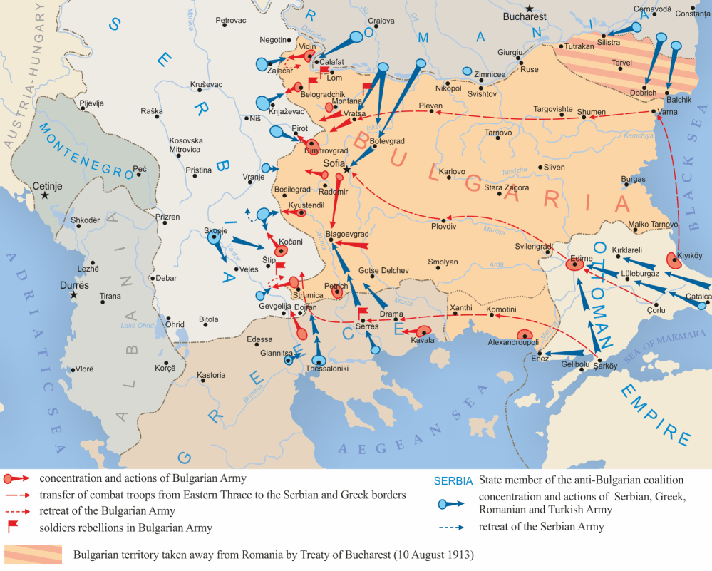
The map illustrates how the Second Balkan War erupted from unresolved disputes over Macedonia following the Treaty of London (30 May 1913), which ended Ottoman rule but left the Balkan allies dissatisfied. Bulgaria, frustrated by the failure of its territorial ambitions and isolated diplomatically, turned against its former allies. On 29 June 1913, Bulgaria launched a surprise attack on Serbian and Greek positions in Macedonia, transforming the earlier “liberation” into open conflict over occupation and control. Fighting was concentrated across Macedonian territory, as Serbian and Greek forces resisted Bulgarian advances, while Romania attacked Bulgaria from the north and the Ottoman Empire re-entered the war to retake Adrianople. Surrounded and exhausted, Bulgaria suffered a rapid defeat. The Treaty of Bucharest (10 August 1913) formalized the division of Macedonia—approximately 50% to Greece (Aegean Macedonia), 40% to Serbia (Vardar Macedonia), and 10% to Bulgaria (Pirin Macedonia)—without Macedonian participation. As front lines shifted, Macedonian civilians were subjected to violence, reprisals, and forced assimilation by competing armies, marking one of the most devastating outcomes of the war. Subsequent treaties, including Constantinople (30 September 1913), confirmed these arrangements and permanently redrew the map of Macedonia, fragmenting its population under new state sovereignties.
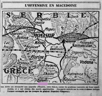
The Macedonian (Salonika) Front in the First World War
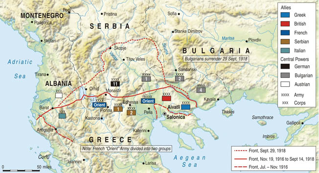
The map shows how geographic Macedonia once again became a major battlefield during the First World War, following barely a year after the Balkan Wars. After Serbia annexed Vardar Macedonia in 1913, the region initially served as a Serbian rear area, but by 1915 it was transformed into an active front when Bulgarian, German, and Austro-Hungarian forces invaded from the north. In response, British and French troops landed at Salonika (Thessaloniki) and established the Macedonian Front, attempting to push north to aid Serbia. Bulgarian forces later advanced deep into Aegean (Greek-occupied) Macedonia in 1916, extending the conflict across the region. As the map indicates, opposing Entente and Central Power lines stretched across Macedonia until 1918, drawing in Serbian reconstituted armies, Greek forces after Greece joined the Entente in 1917, and multinational Allied units. For Western Macedonia, this meant prolonged occupation, militarization, and disruption, as towns and villages lay along or near shifting front lines of a war driven less by local interests than by great-power rivalries and competing Balkan territorial ambitions.
The Presence of Foreign Armies in Macedonia and Zelenich
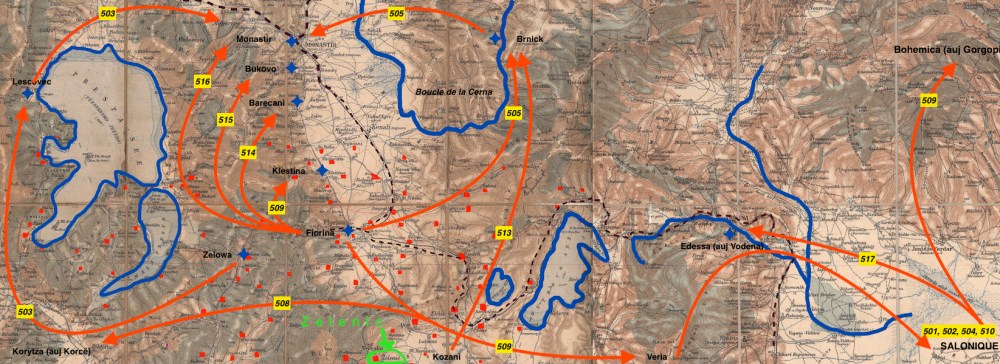
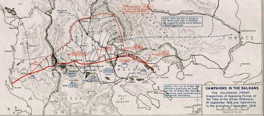
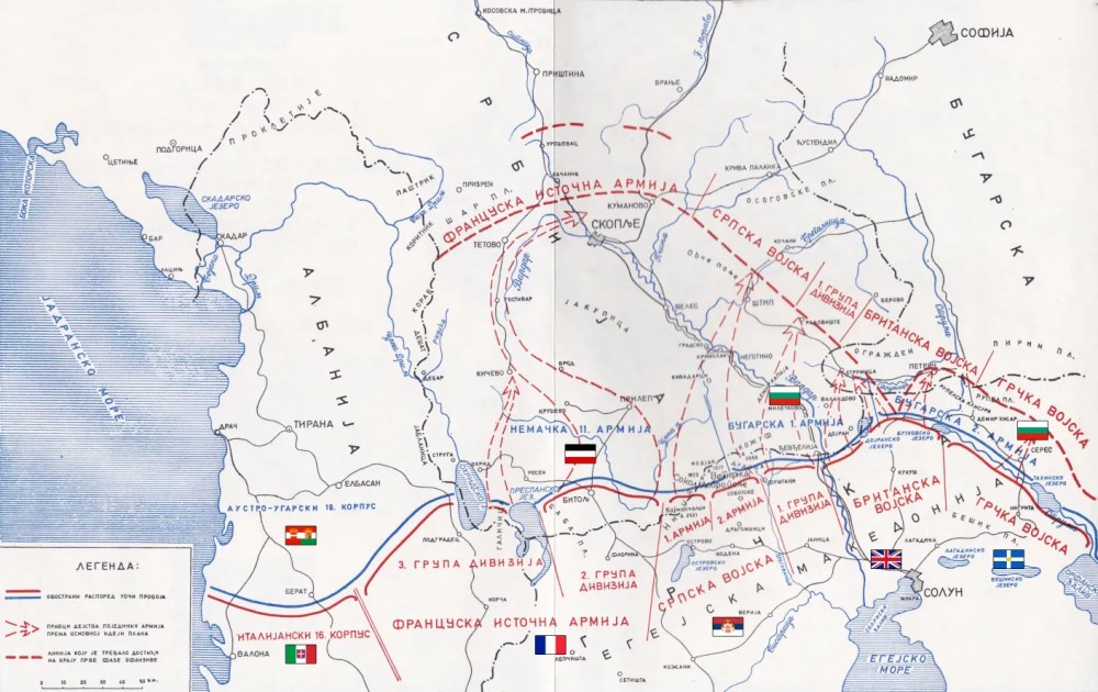
The four maps together show how Macedonia—and villages such as Zelenich (Sklithro)—became embedded within the long-running Salonika (Macedonian) Front during the First World War. From 1915 to 1918, the region hosted a massive multinational Allied presence of roughly 500,000 troops—French, British, Serbian, Italian, Russian, and later Greek—facing Bulgarian forces supported by German, Austro-Hungarian, and Ottoman units. Front lines curved through Western and Central Macedonia, turning the area into a militarized landscape of camps, supply routes, and rear positions rather than constant battlefield combat. Zelenich lay within this Allied zone and hosted a French regiment (about 1,000 men) alongside Serbian and Italian battalions, bringing foreign soldiers into daily coexistence with the local Macedonian population. Beyond warfare, the presence of the Army of the East reshaped village life and the environment: soldiers cultivated vegetable gardens—earning the nickname “gardeners of Salonika”—organized sports, concerts, and performances, and heavily exploited local resources. In Zelenich, French forces cut oak forests on Mount Gradishta for construction and fuel, altering the landscape and contributing to long-term erosion, later mitigated by reforestation efforts in the 1950s. The maps thus capture not only military movements but also how WWI imposed a prolonged social, ecological, and cultural transformation on Macedonian communities that had already endured successive wars.
Greco-Turkish War 1919-1922
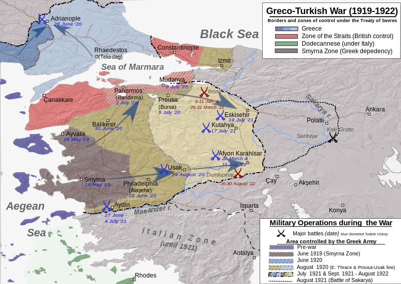
The Greco-Turkish War emerged from the unresolved settlement of the First World War and competing imperial ambitions in Asia Minor, despite President Wilson’s opposition to the dismemberment of the Ottoman Empire and his support for an independent Macedonia. When Greek troops landed in Smyrna on 15 May 1919, backed primarily by British strategic interests, the conflict escalated rapidly as Greek forces pushed deep into Anatolia in pursuit of a “Greater Greece.” This advance provoked fierce resistance from the Turkish National Movement led by Mustafa Kemal, whose guerrilla tactics, Soviet support, and growing popular backing gradually turned the tide. Widespread violence against civilians by both sides intensified ethnic conflict and produced massive refugee flows. The decisive defeat of the Greek army at Sakarya (1921) and the catastrophic Turkish counteroffensive of 1922 forced a chaotic Greek retreat and culminated in the destruction of Smyrna, marking the end of the war and the collapse of Greek expansionist ambitions. Among the fallen were Macedonians from Zelenich, whose names are preserved on local memorials, underscoring how conscription and war were used to bind non-Greek populations to the state, even as they bore a disproportionate share of the conflict’s human cost.
1928 Map
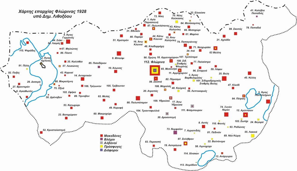
This 1928 map of the Florina region illustrates the profound demographic and cultural transformation imposed on Aegean Macedonia after its partition and annexation by Greece in 1913. Although the region was historically Macedonian-speaking, Greek state policy redefined it as “Northern Greece” and pursued systematic measures to erase its Macedonian identity through expulsions, population exchanges, and forced assimilation. Between 1913 and 1928, tens of thousands of Macedonians were expelled, while the 1923 population exchange brought large numbers of Greek Orthodox refugees from Asia Minor, radically reshaping settlement patterns shown on the map. Land confiscated from Macedonians was redistributed to newcomers, villages were renamed, and Macedonian language and inscriptions were banned or destroyed, including those in churches and cemeteries. The map visually records this engineered demographic shift, marking the transition from a predominantly Macedonian region to one reshaped by state-driven resettlement, cultural suppression, and political control.
The Greco-Turkish Population Exchange (1923)
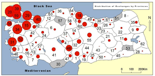
The map reflects how the 1923 Greco-Turkish Population Exchange radically reshaped Macedonia, including villages such as Sklithro-Zelenich, by enforcing compulsory population movements defined solely by religion. Following the collapse of the Greek campaign in Asia Minor and the Lausanne Convention, Orthodox Christians were classified as “Greeks” and Muslims as “Turks,” transforming faith into racial identity for the purposes of nation-building. As a result, approximately 1.2–1.3 million Orthodox Christians from Anatolia and Eastern Thrace were forcibly resettled in Greece, while about 450,000–500,000 Muslims from Greek territory—many native Macedonian Muslims with deep local roots—were expelled to the new Turkish Republic. In Macedonian villages like Sklithro-Zelenich, this meant the permanent removal of Muslim neighbours, the arrival of Asia Minor refugees, the destruction of long-standing social and economic networks, and a profound demographic rupture. The exchange, celebrated as “liberation” in Turkey and mourned as “catastrophe” in Greece, imposed a rigid homogeneity on a previously multi-religious society, leaving enduring social, cultural, and historical scars across Macedonian communities.
Refugees to Zelenich (Sklithro), 1923–1928
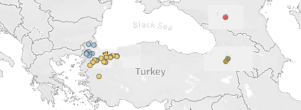
The map traces the diverse origins of the refugee families resettled in Zelenich after the 1923 population exchange, showing arrivals primarily from Asia Minor (Artaki, Sarikeio), Thrace, the Caucasus, and a few other regions. By 1926, the village received 89 refugee families (405 people)—53 Asia Minor families (269), 23 Thracian (93), 10 Caucasian (28), and 3 from other areas (15). By 1928, this stabilized at 87 families with 379 members. Land redistribution followed unevenly: lots were allocated to 55 refugee families and 18 local families, finalized in 1928 with 6,752 acres and 735 sq. m. distributed overall. Refugees integrated into village life as traders and craftspeople—blacksmiths, farriers, butchers—and helped sustain local institutions, including a police station, post office, and a weekly market. While early generations sought to preserve customs from their homelands, by the 1950s these distinct cultural practices had largely disappeared, leaving little visible trace of the refugees’ places of origin in everyday village life.
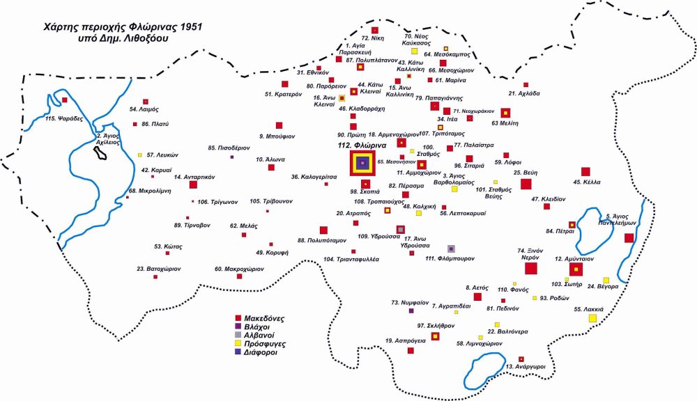
1951 Map